Fascinating Scientific Facts About Texas Geography & Nature
Texas contains 10 distinct ecological regions spanning from dense eastern pine forests receiving up to 55–60 inches of annual rainfall to western deserts getting less than 10 inches. The state covers approximately 268,596 square miles, making it the second-largest state in the U.S. You'll find the terrain shaped by dramatic features like the Balcones Escarpment, where fractured limestone creates artesian springs and cave systems. The Rio Grande forms about 1,254 miles of the international border, while major rivers and natural features help define parts of the state’s boundaries. Guadalupe Peak, the highest point in Texas, rises to 8,751 feet above sea level, highlighting the state’s remarkable geographic diversity.
Texas Spans 10 Eco Regions from Deserts to Pine Forests
View this post on Instagram
Texas’s massive landscape contains an extraordinary variety of environments, divided into 10 ecological regions recognized by the Texas Commission on Environmental Quality (TCEQ). These range from dense forests to arid deserts. You’ll find the Piney Woods in East Texas, where thick forests thrive due to higher rainfall. The Gulf Prairies and Marshes stretch along the coast, providing essential habitat for migratory birds and supporting wetlands ecosystems. Moving west, the Edwards Plateau features aquifer-dependent ecosystems, including springs and underground water systems within the Edwards Aquifer, which support rare species such as blind salamanders. Farther west, the Trans-Pecos region showcases Texas’s most rugged terrain, with elevations rising sharply to Guadalupe Peak (8,751 feet). The High Plains transition into canyon systems like Palo Duro Canyon, while the Rolling Plains introduce mesquite grasslands and prairie ecosystems. These regions are defined by soil composition, rainfall patterns, elevation, and temperature, which together shape each area's distinct environmental character.
East Texas Receives Up to 60 Inches of Rain While West Gets Under 10
View this post on Instagram
Texas experiences one of the sharpest rainfall gradients in North America. East Texas can receive 55–60 inches of rain annually, while parts of far West Texas average less than 10 inches per year. Cities like Beaumont and Orange are among the wettest in the state, while El Paso averages around 8–9 inches annually. This dramatic shift occurs gradually across the state and plays a major role in agriculture, vegetation, and water supply. Locations such as Sam Rayburn Reservoir often see over 50 inches of rainfall annually, while areas near Big Bend and Lajitas remain extremely dry. The Gulf Coast also shows variation, with Southeast Texas receiving significantly more rainfall than the lower Rio Grande Valley. These differences strongly influence urban development, farming practices, and water management, shaping everything from crop selection to city growth.
Texas Has Aquifers: Hidden Water Systems Beneath the Surface
View this post on Instagram
Texas’s water systems extend far below the surface through major underground reservoirs known as aquifers, which supply drinking water, agriculture, and industry across the state. Two of the most important are the Edwards Aquifer and the Ogallala Aquifer. The Edwards Aquifer lies beneath Central Texas and is one of the most productive artesian aquifers in the world. It feeds major springs such as Comal Springs—the largest spring system in Texas—and San Marcos Springs, supporting both human populations and rare aquatic species. In contrast, the Ogallala Aquifer underlies the High Plains of West Texas and supports large-scale agriculture. However, unlike the Edwards, it recharges very slowly, making it vulnerable to depletion from irrigation use. These aquifers play a critical role in shaping settlement patterns, agriculture, and long-term water sustainability across Texas.
Texas Climate Zones Reflect Its Geographic Diversity
Texas spans multiple climate zones, reflecting its vast size and varied terrain.
- Humid Subtropical (East Texas & Gulf Coast): Characterized by hot summers, mild winters, and high humidity, with abundant rainfall supporting forests and wetlands.
- Semi-Arid (Central & North Texas): Transitional conditions with moderate rainfall, supporting grasslands and agricultural regions.
- Arid/Desert (West Texas): Defined by low rainfall, high evaporation rates, and wide temperature swings, typical of the Chihuahuan Desert.
These climate zones influence everything from vegetation and wildlife to water availability and land use, reinforcing the strong connection between Texas’s geography and its weather patterns.
The Rio Grande Forms a Major Portion of the U.S.-Mexico Border
View this post on Instagram
Stretching roughly 1,896 miles from Colorado to the Gulf of Mexico, the Rio Grande is one of North America’s longest rivers. It forms about 1,254 miles of the U.S.-Mexico border, separating Texas from the Mexican states of Chihuahua, Coahuila, Nuevo León, and Tamaulipas. The river’s 336,000-square-mile basin supports millions of people across both countries. However, water management remains a challenge due to heavy demand, agricultural use, and periodic drought. International agreements, including the 1944 Water Treaty, govern water sharing between the United States and Mexico. In some stretches, especially in drought conditions, portions of the river experience reduced flow due to upstream usage and irrigation demands. The broader border region is home to over 15 million people, making it one of the most active and populated international boundary zones in North America.
Major Rivers Help Define Texas Boundaries
While surveyed lines determine many borders, several major rivers play a key role in shaping Texas’s geography. Key boundary rivers include:
- Rio Grande – Forms the southern and southwestern border with Mexico
- Red River – Defines much of the northern boundary with Oklahoma
- Sabine River – Marks the eastern border with Louisiana
Together, these rivers contribute significantly to Texas’s natural boundaries. However, not all borders are river-based, as portions of Texas’s western and northern edges are defined by surveyed lines. The Red River boundary dispute between Texas and Oklahoma was resolved through legal decisions and federal rulings, clarifying ownership along the river’s shifting banks.
Coastal Plains Cover a Large Portion of Texas
View this post on Instagram
The Texas Coastal Plains extend from the Rio Grande Valley to East Texas, forming one of the state’s largest geographic regions. This area covers well over one-third of Texas, making it the most expansive natural region in the state. You’ll find elevations gradually decreasing from inland areas down to near sea level along the Gulf Coast. Landscapes include prairies, marshes, forests, barrier islands, and bayous, supporting rich biodiversity. Rainfall in this region typically ranges from 30 to over 50 inches annually, creating humid conditions that support agriculture and dense vegetation. The region is also underlain by sedimentary rock formations that slope gently toward the Gulf of Mexico. Major metropolitan areas such as Houston, Corpus Christi, and Brownsville are located within this region, contributing to its high population density and economic importance.
The Balcones Escarpment Divides Hill Country from Coastal Plains
Running from Del Rio through Austin and into North-Central Texas, the Balcones Escarpment forms a prominent geological boundary between the Edwards Plateau and the Coastal Plains. This fault zone developed millions of years ago and created a noticeable elevation change that defines much of Central Texas’s landscape. The escarpment is responsible for:
- Major spring systems such as Barton Springs, Comal Springs, and San Marcos Springs
- Karst features including caves and sinkholes
- Steep terrain and scenic hill country landscapes
Cities like Austin and San Antonio developed along this boundary due to reliable access to spring-fed water. Although the fault is geologically significant, it is considered relatively inactive, with minimal earthquake activity in recorded history.
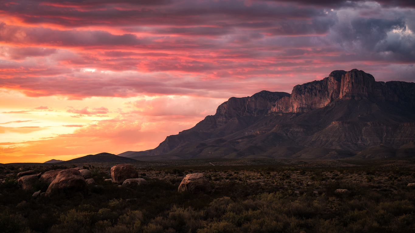
Guadalupe Peak Is the Highest Point in Texas
View this post on Instagram
Rising to 8,751 feet, Guadalupe Peak is the highest natural point in Texas and is located within Guadalupe Mountains National Park in Culberson County. Nearby peaks, including El Capitan (8,085 feet), form part of an ancient reef system that dates back to when the region was covered by a prehistoric sea. The Guadalupe Mountains extend into New Mexico, and their exposed limestone formations create dramatic cliffs and canyons. The peak is accessible via an 8.4-mile round-trip hike, making it a popular destination for hikers. Its location about 90 miles east of El Paso places it within the rugged Chihuahuan Desert, creating a striking contrast between desert lowlands and high-elevation ecosystems.
Palo Duro Canyon Is the Second-Largest Canyon in the U.S.
Located near Amarillo in the Texas Panhandle, Palo Duro Canyon stretches approximately 120 miles long, up to 20 miles wide, and reaches depths of around 800 feet. It is widely recognized as the second-largest canyon in the United States, after the Grand Canyon. Visitors to Palo Duro Canyon State Park can explore:
- Over 30 miles of trails for hiking, biking, and horseback riding
- The iconic Lighthouse rock formation
- Diverse wildlife including mule deer, roadrunners, and Texas horned lizards
- The long-running “TEXAS” outdoor musical, performed during summer
The canyon’s layered rock formations reveal millions of years of geological history, making it both a recreational and scientific landmark.
Desert Landscapes Shape West Texas
Desert environments play a major role in Texas geography, especially in the Trans-Pecos region of West Texas. The Chihuahuan Desert is the dominant desert ecosystem, covering much of this area and extending into Mexico and New Mexico. It is the largest hot desert in North America. Other semi-arid regions in Texas include:
- South Texas Brush Country – Known for thorny vegetation and wildlife habitat
- High Plains – Features elevated grasslands with semi-arid conditions
These regions support specialized plant life such as creosote bush, ocotillo, and cacti, all adapted to extreme heat and limited rainfall. While these areas are less densely populated, they are ecologically significant and home to unique biodiversity found nowhere else in the state.
Related posts